Ithaca to Seattle
in 4,000 Miles or More
August 15: Ithaca, NY
The last rent is paid. The apartment’s walls are bare except for the shadowy marks of masking tape and empty nail holes. All of my worldly possessions are packed in boxes scrounged from Cornell University Press and Triphammer Wines & Spirits. Mom has performed her special voodoo to make everything fit in one mini van and half an Acura, and Mai and Bruce, experts at moving, have whisked away superfluous junk. I’ve said my good-byes to the hearteningly enthusiastic Varna fencers and emptied my locker in Stifel Salle. Time to reset the odometer, reset my life, and head westward to see what happens next: through the cornfields of the Midwest, the grasslands of the Great Plains, the sagebrush of the West, the passes of the Rockies and Cascades, and, finally, Seattle. Here’s to a grand adventure across the Land of Opportunity.
We begin on Route 13 through Ithaca, reversing the route of my arrival four years earlier. A parade of landmarks rolls by:
- The view across sparkling Cayuga Lake to the Museum of the Earth, whose basement I reorganized, and Cayuga Medical Center, whose cafeteria I patronized thereafter.
- The Sceincenter’s chain-link fence, which I ripped a decade’s worth of greenery from and spraypainted black.
- Ithaca Bakery, the source of the chocolate croissant in my passenger seat.
- The Friends of the Library warehouse, site of the nation’s largest used book sale.
- The Big Orange Box. No tears shed.
- Dirt roads leading to the Finger Lakes Trail, Upstate New York’s section of the North Country Trail. Theoretically, one could walk from Pleasant Grove Road to North Dakota, but not with a dresser and coffee table. We’re driving.
- Arnot Forest, where the STS Department holds its annual retreat in a flimsy cabin used mostly by Scout troops.
- The overlook from which, four years ago, I first saw Ithaca, the hilltop towers of Cornell and Ithaca College poking through the trees and Cayuga Lake curving into the distance.
- I-90 stretching toward the setting sun.
.JPG)
August 16: Bear Lake, MI
August 19: Pictured Rocks National Lakeshore, MI
Vertical sandstone cliffs dye Lake Superior a Caribbean blue here in Michigan’s Upper Peninsula. Between cliffs, the land slopes down to meet the water at sandy beaches. Forty-two miles of the North Country Trail (New York to North Dakota) follow the shore, offering backcountry campgrounds every four or five miles.
When I pick up a two-day backcountry permit in Munising, MI, the campgrounds two, five, ten, twelve, and thirteen miles away were all full. A site fifteen miles away was open due to a cancellation. Thankfully, fifteen miles on professionally maintained, high-traffic, relatively flat trail is a reasonable tramp. I take eight hours, including lunch and photography stops.
Sand is everywhere. The trail itself is sand: loose beach-sand, good for exercising the ankles, for the first few miles east of Miners Castle Trailhead, then compacted sandy soil in a sunny Eastern hardwood forest. How pleasant, to walk in a place full of familiar beeches and trilliums and grouse that I’ve come to know so well on Ithaca’s Finger Lakes Trail.
On the second day, it rains. What an appropriate segue from East to West.
August 22: Waukesha, WI
Amy's Feast is the stuff of legends. Its praise will be sung for generations.
August 27: Minneapolis/St. Paul, MN
Food on sticks, pegs in wood, people on ropes, and the mythical Source of Post-Its: My intrepid college roommate and I spend the weekend eating our way through the Minnesota State Fair (second-largest state fair, after Texas, and, well, it's Texas), learning cribbage, hanging out (ha ha) at a climbing cliff at Taylors Falls, and visiting the 3M company store. Minnesota, hats off to thee...
September 1: Boundary Waters, MN
.JPG)
Someday we’ll tramp the length of the Kekakabic Trail, from Snowbank Lake just east of Ely, MN, thirty-eight miles east to the Gunflint Trail, but not this year. This year, we go east for two days along the Kek, then return by way of two short loops. Campsites range from beautiful lakeside clearings with room for a Scout troop’s tents to one particularly underused site featuring a sapling growing up through the fire grate and a privy lost to the woods. Trail quality also varies. The Kek itself does a good jungle impression. Often we can’t see our feet for the underbrush, and the greenery reaches for us from either side. There may once have been trail signage. Now, the trail is visible only as the ancient remains of a logging road, a marginally open space between mature trees, overtaken by saplings and shrubs. Trail quality decreases from there. The remoter stretches of the loop trails have us climbing over, crawling under, and bushwhacking around uncountable treefalls. But that’s what we get for hiking in canoe territory.
.JPG)
However, we do see surprisingly many other hikers. One older man interviews us on a tiny camera looped around his neck about our impressions of trail conditions. He represents the Boundary Waters Advisory Committee and suggests that we write a report to the Forest Service about our difficulties. The more hikers the Forest Service hears from, the more they realize that we do exist and that we do appreciate trail maintenance.
Highlights of our tramp include:
- Perfect weather.
- No ticks.
- Eating flattened Little Debbie cupcakes in the middle of the wilderness.
- Discovering that my dirty socks stick to tree trunks, useful for drying laundry.
September 8: Theodore Roosevelt National Park, ND
The rolling prairie drops away on the western border of North Dakota, revealing a messy pothole of badlands. The Little Missouri River wanders through the bottomlands, creating a muddy strip of cottonwoods in this otherwise dusty land of juniper, sagebrush, and grasses. Colorful but pale, striated cliffs rise to dry, hillocky grassland. Here graze bison, elk, wild horses, and mule deer, and prairie dogs chirp from cities of holes that sprawl across flat valleys.
.JPG)
What a change from the jungle-like Boundary Waters. We can see for a mile on our day hike but occasionally loose the trail because the grass grows too sparsely to define a path. In other places, the trail has been eroded by feet, hooves, and gushes of sporadic rainwater into a two-foot-deep gorge, a miniature of the surrounding cliffs. Part of our trail crosses a wildly meandering creek half a dozen times. Unfortunately, it rained yesterday. By the time we give up jumping across and march straight through the ankle-deep water, our boots are caked in thick, slimy clay from slipping and sliding on the steep banks while clinging to prickly juniper and sage roots in hopes of keeping upright. To bad the opaque water does little to wash our boots.
September 9: Montana
Here, in Montana, is the West. Most highway exits bear "No Services" signs. Many are labeled simply "Ranch Access." On- and off-ramps have cattle grates.
This is also the fabled origin of I-94. This familiar highway has taken care of us for so many miles and so many years. As children, we traveled on it between home and our grandmother’s house in Detroit. It got me to fencing practice in Milwaukee and tournaments in Chicago. It ferried my sister and I to college in Madison and Minneapolis. Today, it has escorted us safely across the Great Plains and must now leave us in the hands of another. At Exit 0, just east of Billings, Montana, we left I-94 and merged smoothly onto the Great I-90. Stretching from Boston on the Atlantic to Seattle near the Pacific, I-90 is the longest interstate highway in our wide country. It appears as a tollway across Upstate New York and joins I-94 for several miles in mid-Wisconsin, so we know we will be okay. I-94 becomes yet another familiar thing I am leaving behind in order to make my way in the West.
September 10: Eastern Washington
The West is dry and hot. The never-clouded sun sears our left arms. Our sweat evaporates as soon as it contacts the air.
Idaho rolls by around midday in the form of a deep-blue arm of the sprawling Coeur d’Alene Lake, filling a maze of steep-walled valleys. Spacious houses line the forested banks, probably weekend homes for Missoula and Spokane residents, and pleasure boats throw showers of spray. Oh, to be immersed in clean, cold water! But we need more miles behind us today.
After Idaho, the terrain flattens to a tabletop and colors evaporate from the landscape. Only dead-grass-yellow and sagebrush-grey remain—hardly the "evergreen state" advertised by the state license plates. Instances of civilization appear rarely: a sun-bleached farmhouse huddled next to the only two trees in sight, a patch of cell-phone towers crowded onto a very slight rise several miles away. Even cattle ranchers seem to avoid this desert plateau. My nose and throat feel dry and gritty, and invisible dust coats every surface.
Potholes State Park, today's destination, is a man-made oasis. The park uses water from Potholes Reservoir in its underground sprinkler system. On one side of the road, RVs lounge on lush, squared-off lawns. On the other side, pale sagebrush and tan dirt-dust cover the land. After hastily pulling on swimsuits, we head straight for the beach—where our dreams of refreshing water are dashed on mucky mudflats and algae. How we miss Pewaukee Lake, fifteen hundred miles behind us. We give up and return to the shade of our campsite’s artificially healthy trees.
The Potholes region is, incredibly, farming country. Tractors drive through potato fields trailing plumes of tan dust that hang in the still air. Farther on, we stop at a refreshingly colorful fruit stand in the midst of a strangely green orchard. The farmer gives us samples of sweet, juicy melon, and we buy peaches and nectarines and pears. The farmer explains that he moved here from Detroit "when the water came"—when they dammed the rivers to bring agriculture to the desert. From there to the Columbia River, we follow a truck so full of onions that they bounce out of its topless bin onto the roadside. Apparently the dams have also brought surplus and waste to the desert.
September 11: Mount Rainier National Park, WA
Along our route, the Rockies have been mostly a series tall hills surrounding long, flat valleys. The Cascades, though, are true mountains: jagged peaks, dizzying drops into narrow river valleys, glacier-capped volcanoes. Rainier itself looks down upon so much of Washington’s population that its portrait graces the state’s license plates.
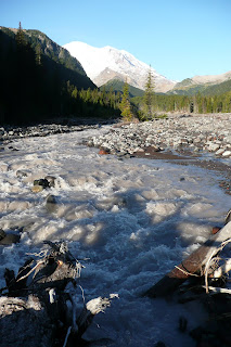
We camp in a crowded but quiet place on the northeast slopes of "The Mountain." Thin, scraggly pine trees are full of Steller's Jays, the West's black-headed answer to Blue Jays, and a bold flock of scavenging Grey Jays. We fall asleep to the rushing of the White River, a small stream whose opaque, grey waters must fill its broad, rocky bed with whitewater in the springtime. Several groups of climbers pass our site, ice axes, crampons, and helmets strapped onto heavy-looking packs, heading cheerfully toward the mountain and quietly back from it. In the morning, we hike around Sunrise, where Rainier gifts us with a cloudless sky and overlooks of too much depth and breadth for our overworked cameras to capture. If I were superstitious, I might have imagined that I was making a pilgrimage to Rainier as the patron-spirit of the place that I hope to call home.
September 12: Port Orchard, WA
After 4,353.05 miles and nearly a month of travel, the brave little Acura rolls safe and sound into my sister’s apartment complex in Port Orchard, Washington. I smell pine and saltwater. The Olympic Mountains provide a jagged horizon in the northwest. Seattle is hidden behind the many peninsulas of Puget Sound. I'll travel there soon enough on the search for employment, but for today, we simply enjoy not driving.
Thanks to everyone for being so supportive of this crazy adventure and for providing me with housing, entertainment, and friendship along the way. We'll see what happens next.


.JPG)
.JPG)
.JPG)
.JPG)
.JPG)
.JPG)
.JPG)
.JPG)
.JPG)
.JPG)
.JPG)
.JPG)
.jpg)
+crop.jpg)


